Rapidly Intensifying Hurricane Milton Forecast to Make Landfall Wednesday

Image: NOAA
The Climate Adaptation Center—which will hold its fourth annual Florida Climate Conference on Nov. 14-15—has been issuing updates as we learn more about Hurricane Milton. Here's the latest from meteorologist and CAC founder and CEO Bob Bunting,
Hurricane Milton is rapidly intensifying over the southwest Gulf of Mexico. That means major impacts from hurricane-force winds, storm surge and excessive rains are likely Wednesday.
As I indicated on both Friday and Saturday, Milton will likely become a major hurricane (category 3 or higher) in the Gulf of Mexico and approach the Suncoast with the potential of a direct hit on Wednesday.
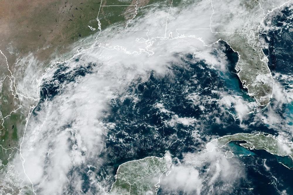
Compared to Debby and Helene, Milton is currently small and size and the storm will have its own personality—some of which is now evident.
Milton will be a concentric, classic-looking hurricane, as you can already see on the satellite image below. The storm is very symmetrical and is taking on power quickly and effectively as it begins moving east-southeast across the southern Gulf of Mexico.

By late tomorrow, the storm will probably reach Category 3 status—and there are signs it may grow stronger than that.
Early morning data showed an eye forming. Having a good fix on the eye will help focus the forecast cone, which is already happening. There has been some movement of the cone north and south over the past day, but right now, it is still very close to where it was yesterday. The center of Milton is likely to be within the cone, but expect adjustments over the days ahead. And at this point, the adjustment should be within about 100 miles either way.
What is clear is this: a very unusual path is taking shape in which the storm moves across the Gulf of Mexico from west to east, over a very warm loop current and warm waters in the Gulf. On the Suncoast, we are not used to having storms approach the coast from this trajectory. In my view, this is rather unique and dangerous at the same time.

Image: NOAA
Its expected approach path gives Milton lots of time to suck up energy with an optimal concentric shape and low to moderate wind shear. There is very little veering of the winds from the surface of the water to the top of the hurricane. Unfortunately, this is pretty much an ideal development environment.
Warnings and watches are forthcoming from the National Hurricane Center.
Major storm surge, highly destructive winds and excessive flooding are all likely in and around the storm's landfall location, with serious impacts far from the center. Don't focus just on the cone!

Storm surge is a significant concern. While the first estimates have not been posted by the National Hurricane Center yet, this image (above) shows widespread storm surge potential all along the coast, with our Sarasota metro area quite vulnerable.
As we have learned, even oblique hits by Hurricanes Idalia and Helene caused major to historic storm surges along the barrier islands. A direct hit will mean even worse impacts close to where the center comes ashore. Plus, sea level has risen 9 inches since 1950, making these surges more severe.
Wind will be an issue, too. I expect Milton to grow in size as it nears Florida's west coast. It would not be at all surprising to see our entire metro area experience hurricane force winds and/or wind gusts.
Fortunately, there is still time to prepare. Here's what to do:
Secure Loose Objects
It is very important that anything not securely attached be removed and put away so these objects do not become missiles in high winds.
Do Not Wait to Evacuate
Don't wait to evacuate until evacuation notices are given. Remember, many of our evacuation routes have not been raised and will become flooded well before the hurricane arrives.
Know Your Elevation
If a 6-foot storm surge is forecast and you are at sea level, then you are putting yourself in a lethal situation. We just saw this with Hurricane Helene. Be smart, and do the math.
Our communities are mobilizing. Be part of it and take the advice of officials. The average error in track forecasts is about 100 miles right now. Milton's path could shift, but if even it doesn't, you will still have major impacts. Be prepared!
Bob Bunting is a scientist, entrepreneur and educator, and the CEO of the nation’s first Climate Adaptation Center (CAC), headquartered in Sarasota. The Climate Adaptation Center is an expert resource to inform government, academe, the private sector and philanthropy so they can create the necessary adaptation strategies and actions to protect the Florida way of life and foster the climate economy while larger global solutions evolve to solve the climate problem. Its fourth annual Climate Conference takes place Nov. 14-15. Contact Bob at [email protected] for more information.