Climate Adaptation Center Releases 2026 Hurricane Forecast

Sarasota's Climate Adaptation Center (CAC) released its annual forecast for the 2026 Atlantic hurricane season this week.
The verdict? The CAC predicts 12 named storms, five hurricanes and two major hurricanes (Category 3 or higher).
What Factors Will Contribute to the 2026 Storm Season?
Hurricanes thrive under specific conditions. According to the CAC, these five areas will impact the scope and strength of the 2026 season.
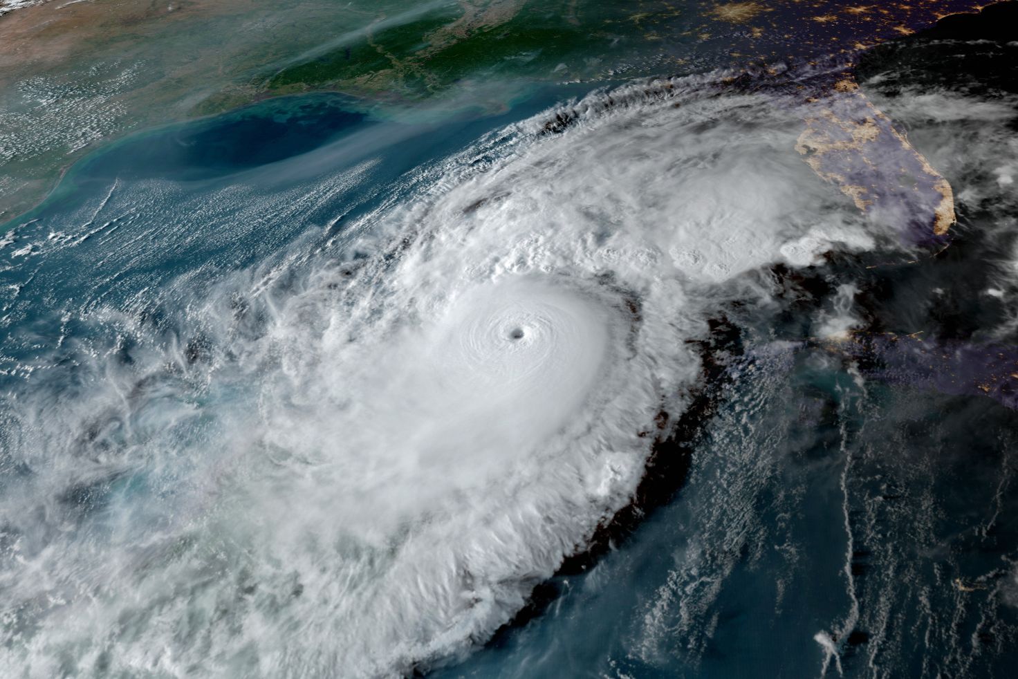
Sea Surface Temperatures (SSTs)
Warmer-than-average SSTs provide more energy for storm formation and intensification—that is, an increase in a storm's maximum sustained winds of at least 35-40 mph within a 24-hour period.

Current data indicates that SSTs—particularly in the Gulf of Mexico and Caribbean Sea—will be very warm this season, enhancing the likelihood of active rapid intensification (RI) if a storm crosses the Gulf this year, like Milton, Helene and Debby did in 2024. That means that when storms rapidly intensify near a coastline, they can strike with devastating impacts that leave little time to fully prepare.
Ocean Heat Content (OHC)
When the temperatures of the sea are warm several hundred feet beneath the surface, that pool of warm water acts like rocket fuel for hurricanes—especially in the absence of wind shear.

Image: Courtesy Photo
A water temperatures of 26 degrees Celsisus is the magic number for hurricane formation—and that temperature is not only present on the ocean surface, but as far down as 300 feet. As spring turns into summer, expect this deep warm water area to expand.
Atlantic Multi-Decadal Oscillation (AMO)
Atlantic Multi-Decadal Oscillation is the measurement of the variability of sea surface temperatures over decades of time; it includes a cool phase and a warm phase. This year, the AMO remains in a warm phase, which historically correlates with higher hurricane activity and tropical cyclone development.
Looking at the dashed line in the image above, one can see how the actual warming is higher than most models and analogue years can now predict. In other words, the models are, for the most part, under-forecasting the strength of the AMO. The red horizontal line shows the delineation between warm phase and cool phases.
The takeaway? The Atlantic remains in a very warm phase—a positive factor for storm development.
Bermuda-Azores High
A weaker Bermuda High, a high pressure system, typically steers storms northward earlier in their path, which may shift storm trajectories and decrease direct impacts on the southern U.S. coast.

Image: Courtesy Photo
In 2025, the Bermuda High was over the Azores and kept the season's four major hurricanes away from the Gulf by shunting them to recurve off the U.S. Atlantic coastline. In 2026, indications are that the High will have two centers. That means that some of the storms will move more westward toward the Gulf.
El Niño Southern Oscillation (ENSO)
The ENSO condition is has evolved from a La Niña condition, which is favorable to hurricane formation, to a neutral condition. But an El Niño, and perhaps a strong one, should be developing over the next three to six months. That timing will shape the coming storm season.

Image: Courtesy Photo
The graphic above shows the present SSTs in critical area for ENSO. One can easily see the Pacific is warming, and all the spaghetti forecast models also show major warming though hurricane season. The red "S" on the left-hand ordinate is the demarcation line for a Super El Nino, and some models are indeed forecasting a Super El Nino during peak hurricane season.

Image: Courtesy Photo
In any event, the occurrence of an El Nino is highly correlated to increased wind shear and fewer storms.
Wind Shear
Because El Nino conditions are likely to form this year, wind shear is predicted, which also creates a unfavorable environment for storm development.
When winds increase with height from the same or different directions, it tends to blow the center axis of a storm downwind. Low wind shear is the most efficient environment for hurricanes, because the center of the storm can build up vertically. That makes it an efficient energy conservation machine and increases the spin around the eye.
Think of an ice skater spinning. At first the spinner, is doing so slowly. But as the skater brings in their arms and stands up straight, the spin increases. It’s the same thing with storms, and it's known as "the conservation of angular momentum."
Mid-Level Moisture
Mid-level moisture is an important parameter for storm formation, too. The story starts with African easterly waves that move across the Sahel, a 2,400-mile-wide, semi-arid transition zone in Africa that separates the Sahara Desert to the north and the Sudanese savanna to the south.

Image: Courtesy Photo
When the area in orange (above) is wet, the dust cloud from winds blowing across this semi-arid region is suppressed. When dust is limited, hurricanes have more mid-level moisture to help them grow. The forecast from our national climate model shows a large green and blue area that indicates excessive rainfall in August 2026.
If accurate, more moisture will be available to the easterly wave storm systems emerging into the Atlantic, which would aid hurricane development as peak hurricane season begins.

Image: Courtesy Photo
Looking at the big picture for the main development region for hurricanes (above), there appears to be large swaths of heavy rainfall suggesting lots of moisture availability, especially in June. With this pattern and an emerging but not yet established El Niño, June could be a month of concern for the west coast of Florida.

Image: Courtesy Photo
The red arrow is where storms could pass that can create this kind of heavy rain. Keep in mind that September is peak hurricane season.
Taken together, it appears there will some mid-level moisture before El Niño is fully established and suppresses storm formation. While it's best not to take any of these graphics as absolute, given hurricane season begins in June, they are providing important input to the CAC forecast.
In Summary
The 2026 Atlantic hurricane season looks like it will be below-average in terms of storm formation. But remember: it doesn't take a direct hit for the Suncoast to experience extreme impact. Hurricanes Idalia and Helene were far from the coast, but caused millions of dollars in damage. That's driven by the fact that today's hurricanes are bigger, slower-moving and happening on top of 7 inches of sea level rise since 2000.
Another point to keep in mind: Wind shear ebbs and flows, no matter what is happening with El Niño. Should a period of weak shear happen and a storm moves into the Gulf over the deep warm water, rapid intensification can—and most likely will—occur. This is something to watch very closely.
What About This Year's Storm Names?
This year's names are Arthur, Hanna, Omar, Bertha, Isais, Paulette, Cristobal, Josephine, Kyle, Leah, Marco, Nana, Paulette, Rene, Sally, Teddy, Vicky and Wilfred.
Preparing for Storms
Preparedness is the key to safety during hurricane season. Make sure to create an emergency plan; build a hurricane kit with food, water, important medications and documents; secure your home; know your evacuation zone and nearby shelters; and have a plan for after the storm has passed. For a full list of tips, click here.
Bob Bunting is a scientist, entrepreneur and educator and the CEO of the Climate Adaptation Center (CAC), headquartered in Sarasota. The Climate Adaptation Center is an expert resource to inform government, academe, the private sector and philanthropy so they can create the necessary adaptation strategies and actions to protect the Florida way of life and foster the climate economy while larger global solutions evolve to solve the climate problem.