


Tropical Storm Eta Takes Aim at South Florida

Eta moving over Nicaragua.
Image: NASA
Since May, I have been forecasting that this hurricane season would be another for the record books. Hurricane Eta, one of the most rapidly intensifying storms in history and the 28th tropical storm of the season, tying a record for most storms in a season, has just ravaged Central America and is now back in the Caribbean Sea much diminished after two days over land. Most of the area affected by the storm is now cut off from communications and the real impact won’t be known for some time.
Already there are signs that Eta, the second most intense November hurricane in history, is building new strength over very warm tropical waters. Indications are that it will regain near hurricane to hurricane strength as it crosses Cuba, threatens south Florida late this weekend. Eta may brings gales and big tides and associated beach erosion to the Sarasota-Bradenton area next week.
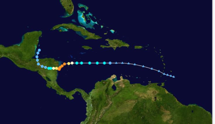
Hurricane Eta's path so far.
Image: Courtesy Photo
The Climate Adaptation Center has been informing our region about disruptions due to unprecedented climate warming in Florida over the past several decades; one of the biggest changes is how hurricanes are behaving.
Eta is a perfect example. It intensified with breathtaking speed, going from a depression to a strong Category 4 in just 36 hours, making evacuations in heavily populated areas difficult. When all is done, it may be that Eta was a Category 5 when it made its first landfall.
Explosive intensification, an increase in wind speed of over 35 mph in a 24-hour period, used to be rare. This season it has happened nine times. The Weather Channel provided this graphic, which shows the name of the 2020 tropical storm and its maximum 24 hours intensification in mph.

Explosive intensification has been a major theme in this year's storms.
Image: Courtesy The Weather Channel
A pinhole eye just 10 miles wide meant the area near Eta’s landfall in Nicaragua was struck by a tornado like the central eye core with winds gusting to 175 mph; an EF3 tornado intensity. It also stalled over land for two days, subjecting parts of Central America to catastrophic floods, winds and storm surges for days.
Now it’s heading toward a cooling but still warm Gulf of Mexico on an erratic slow path that will cause fits in south Florida from Sunday to Wednesday next week. Exactly how long it stays, how erratic the movement and if it goes over land in South Florida will determine impacts here.
At a minimum, our region should expect heavy rains, gale force winds and beach erosion. Further south in the Keys and South Florida, hurricane force gusts, higher tides and heavier rains will potentially cause more serious issues.
I am concerned that this storm over a Gulf of Mexico that is still close to 80°F from Sarasota southward could mean a full hurricane intensity upon initial landfall. Pay attention.
Bob Bunting is a scientist, entrepreneur and the chief executive officer of Sarasota’s Climate Adaptation Center, an expert resource for government, academia and the private sector to create the necessary adaptation strategies and actions to protect Florida’s way of life. The center provides support for the emergence of the climate economy and is currently raising $2 million in private donations to kick off its mission.