


What You Need to Know About Tropical Storm Eta
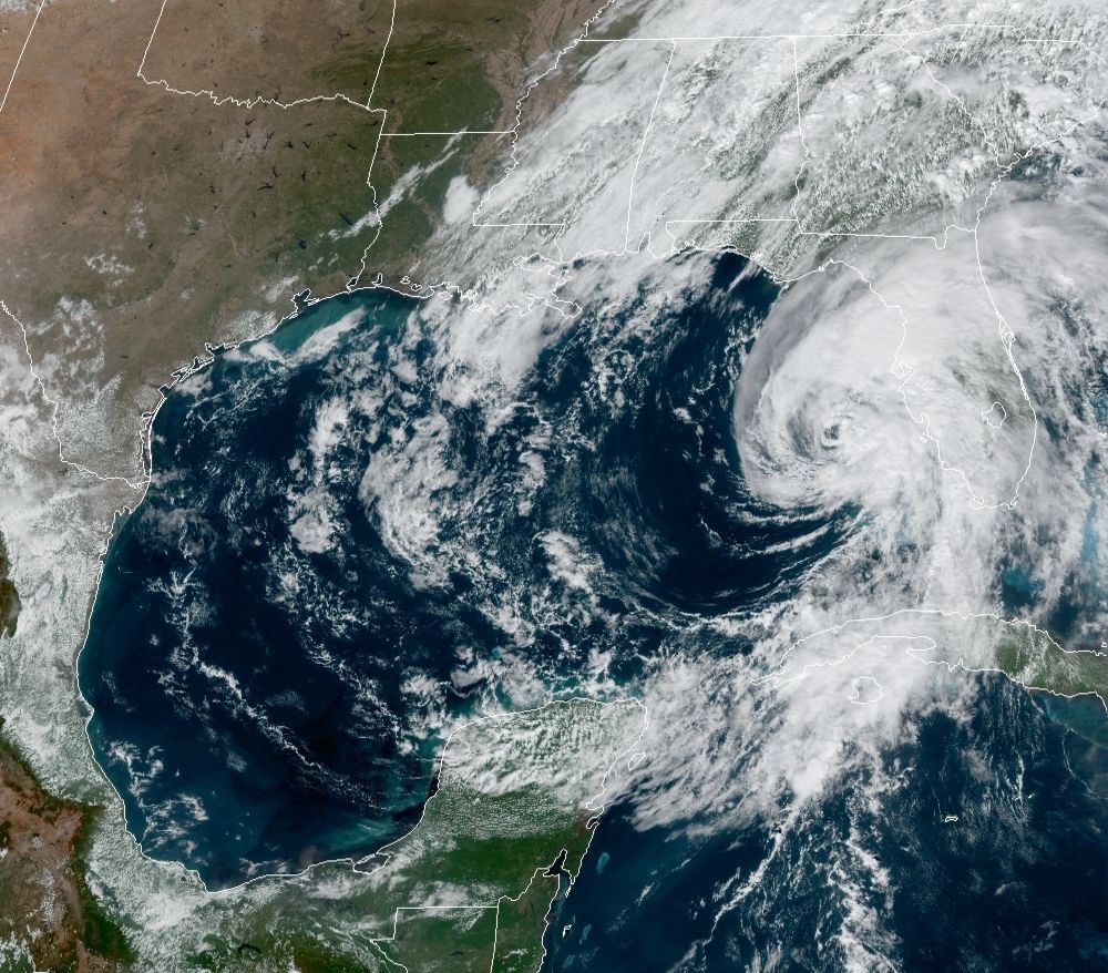
Hurricane Eta on Nov. 11, 2020
Image: National Hurricane Center
Sarasota and Manatee counties are under a tropical storm warning as Tropical Storm Eta churns in the Gulf of Mexico. The storm, which currently has 70 mph winds, is projected to make landfall near Tampa.
"The center of the storm is going to be fairly close to the shoreline," says Bob Bunting, weather scientist and CEO of Sarasota's Climate Adaptation Center. "There will be some chances for brief tornadoes in stronger thunderstorms, and flash flooding will also accompany heavy squalls. It looks like our region will feel the worst of it between 4-8 p.m., and if we experience storm surge, it will be around 7-8 p.m. tonight, as of right now, when we're on the back side of the storm."
Bunting adds that we should expect squalls throughout the afternoon due to the storm's spiral bands, and that even a 20-mile change in Eta's path could change the forecast significantly. "All of the weather in this storm is east and northeast, and that's the quadrant we're in," he explains. "I wouldn't be surprised if we get 5 to 6 inches of rain. We're going to have heavy weather no matter what happens."
We'll be updating this post throughout the day, and in the meantime, stay tuned to these resources for news updates and safety advisories:
National Hurricane Center at the National Oceanic and Atmospheric Administration (NOAA)
Sarasota County Emergency Services (Twitter, Facebook)
Manatee County Government (Twitter, Facebook)
Flash Flood, Storm Surge Warnings in Effect Through Thursday Morning
A flash flood warning is in effect for Sarasota County until 1:15 a.m. Thursday, Nov. 12. A storm surge warning is in effect until 4:34 a.m. Thursday.
Posted by Sarasota County Emergency Services on Wednesday, November 11, 2020
Tropical Storm Weather Predicted to Continue Through Thursday
10 PM EST Nov. 11th Key Messages for Tropical Storm #Eta:
— National Hurricane Center (@NHC_Atlantic) November 12, 2020
Tropical Storm conditions are expected along portions of the Florida Gulf Coast through Thursday morning with a danger of life-threatening storm surge in this region including Tampa Bay.
Latest: https://t.co/lQ8WhA2D3G pic.twitter.com/vBwtioUG01
Siesta Drive Closed Due to High Water
Sarasota County police have closed Siesta Drive just east of the bridge due to high water from Tropical Storm Eta.
🚨ROAD CLOSURE🚨 Siesta Drive is closed just east of the bridge due to high water. Please find an alternate route. #Eta #Sarasota pic.twitter.com/1cGxMKlQzl
— Sarasota Police Department (@SarasotaPD) November 12, 2020
Storm Surge Floods Bradenton Beach Home, Killing One Person
The National Weather Service has reported that storm surge from Tropical Storm Eta flooded a house on Bradenton Beach in Manatee County. When the storm tide entered the home at approximately 6 p.m., a person was fatally electrocuted.
Sarasota Police Department Restricting Access to St. Armands/Longboat Key, Diverting U.S. 41 Traffic; Flooding Happening at Gulfstream and Cocoanut Avenues
The Sarasota Police Department says that it is restricting access to St. Armands Circle and Longboat Key due to Tropical Storm Eta, and diverting traffic from U.S. 41 onto Main Street or eastbound Fruitville Road due to flooding. "Nearly every Sarasota police officer is working tonight to keep you and your family safe," the police department tweeted.
This is why we’re asking you to stay home during #Eta.
— Sarasota Police Department (@SarasotaPD) November 12, 2020
This is a look at Gulfstream and Cocoanut.
Nearly every #Sarasota #Police officer is working tonight to keep you and your family safe.
We’ll get through this together. pic.twitter.com/SYddneCq5w
🚨ROAD CLOSURES🚨We’re restricting travel on & off the island for residents & emergency traffic only to include
— Sarasota Police Department (@SarasotaPD) November 12, 2020
⚠️John Ringling Causeway Bridge
⚠️Bridge to Longboat near Ken Thompson Pkwy & John Ringling Blvd
⚠️NB US 41 diverted onto Main
⚠️SB US 41 diverted EB onto Fruitville pic.twitter.com/bBIwGmbvY3
Sarasota County Schools to Open on Time on Thursday, Nov. 12
Sarasota County Schools says that, after careful monitoring of Eta’s track and projected impact, it has determined that traditional public schools will be opening on-time tomorrow, as will district offices. Children enrolled in charter schools should check directly with the school to confirm opening time in the morning.
National Weather Service Issues 4 P.M. Update
Tropical Storm #Eta Advisory 46: Air Force Reserve Reconnaissance Aircraft Finds That Eta Has Changed Little This Afternoon. Heavy Rains and Tropical-Storm-Force Wind Gusts Continue Across Portions of West-Central Florida. https://t.co/VqHn0u1vgc
— National Hurricane Center (@NHC_Atlantic) November 11, 2020
City of Sarasota Reports Rough Seas, Flooding on Lido Beach
From City Manager @tombarwin who is inspecting conditions throughout the city. Seas at Lido Beach are rough and unsafe for swimmers and surfers. pic.twitter.com/EyJlFaCnTb
— City of Sarasota (@CityofSarasota) November 11, 2020
City of Sarasota Declares Local State of Emergency
The City of Sarasota has declared a local state of emergency in response to Tropical Storm Eta. The declaration provides the city with more flexibility regarding expenditures and allocating resources, which may be necessary with storm surge from the Gulf of Mexico breaching portions of Ben Franklin Drive, additional localized street flooding, and the potential for wind damage caused by strong wind gusts and tornadoes.
In conjunction with Sarasota County Emergency Management, city staff have been monitoring the storm and began making preparations late last week, including clearing storm water drains, positioning mobile generators in key areas to ensure continuity of utilities services, notifying construction contractors to secure sites and construction cranes and more. Public Works staff will monitor local street flooding closely, particularly at high tide at 9:38 p.m. tonight and 10:14 a.m. tomorrow morning.
Sarasota County Continues to Monitor Storm at Level 1 Activation
Sarasota County continues to monitor #Eta, the Emergency Operations Center is activated to a Level 1.
— SarasotaCountyGov (@SRQCountyGov) November 11, 2020
At this time, Sarasota County has not opened evacuation centers or sand bagging locations. Lifeguards are not on duty & residents should avoid visiting beaches.#SRQCountyES
City of Sarasota Monitoring Flooding on Lido Key
FLOODING - We are monitoring localized street flooding from #Eta on Lido Key and other low-lying areas that traditionally flood during heavy rainstorms.
— City of Sarasota (@CityofSarasota) November 11, 2020
Motorists should avoid these areas and never attempt to drive through standing water. pic.twitter.com/meIzULXW0h
4PM UPDATE: Officers are now diverting traffic between the 900 block and 1100 block of Benjamin Franklin Drive near Lido Beach in the @CityofSarasota due to flooding. Please avoid this area. #Eta #FLwx https://t.co/dpz4UjFyq5
— Sarasota Police Department (@SarasotaPD) November 11, 2020
Eta Downgraded to Tropical Storm, Winds Gust to 45 MPH in Venice
With winds now at 70 mph, Eta has been downgraded to a tropical storm. Here's the latest from the National Hurricane Center:
"At 100 PM EST (1800 UTC), the center of Tropical Storm Eta was located by reconnaissance aircraft, Doppler radars, and satellites near latitude 26.7 North, longitude 83.7 West. Eta is moving toward the north-northeast near 10 mph (17 km/h), and this general motion is expected to continue through Thursday. On the forecast track, the center of Eta will move closer to but just offshore of the coast of west-central coast of Florida today and tonight, and move inland over the northern portion of the Florida peninsula on Thursday. Eta is expected to move northeastward into the western Atlantic late Thursday or early Friday.
"Data from the aircraft and NOAA Doppler weather radars indicate that maximum sustained winds have decreased to near 70 mph (110 km/h) with higher gusts. Slow weakening is expected as Eta approaches the west coast of Florida tonight, followed by rapid weakening after landfall occurs on Thursday.
"Tropical-storm-force winds extend outward up to 115 miles (185 km), mainly northeast through southeast of the center. A wind gust to 40 mph (64 km/h) was recently reported in Venice Beach, Florida, while a gust to 45 mph (72 km/h) was reported by a buoy just offshore Venice Beach.
"The minimum central pressure recently measured by the reconnaissance aircraft was 990 mb (29.23 inches)."
DeSantis Extends Executive Order to Include Sarasota, Manatee; Requests Emergency Declaration From President Trump
Gov. Ron DeSantis has expanded Florida's current state of emergency to include Sarasota and Manatee Counties. DeSantis had previously issued the executive order for counties in South Florida; this morning, it was amended to include Alachua, Broward, Citrus, Collier, Dixie, Gilchrist, Hendry, Hernando, Hillsborough, Lee, Levy, Manatee, Marion, Martin, Miami-Dade, Monroe, Palm Beach, Pasco, Pinellas, Sarasota and Sumter counties. You can read the expanded order here.
DeSantis also sent a letter to President Trump requesting an emergency declaration for Hurricane Eta, the text of which can be found here.
Sarasota Police Department Urges Residents to Stay Home, Avoid Flooded Areas
We’re continuing to see gusty winds & bans of rain move through the @CityofSarasota due to #HurricaneEta.
— Sarasota Police Department (@SarasotaPD) November 11, 2020
We encourage you to stay home if possible. If you must be out & come across flooded roads, turn around. Don’t attempt to go through flooded areas. Turn around, don’t drown. pic.twitter.com/AkZER6g8Dt
National Weather Services Issues Tornado Watch for Suncoast
A tornado watch has been issued for parts of Florida until 5 PM EST pic.twitter.com/i1gyoMLZrz
— NWS Tornado (@NWStornado) November 11, 2020
Sarasota County Emergency Services Provides Updates on Hurricane Eta
Sarasota County continues to monitor Hurricane Eta, the Emergency Operations Center is activated to a Level 1. Please...
Posted by Sarasota County Emergency Services on Wednesday, November 11, 2020
Manatee County Issues Eta Preparedness Tips
11/11/20, 11 a.m. #Eta Updates - Voluntary evacuation notice for residents of Anna Maria Island and other low-lying,...
Posted by Manatee County, Florida Government on Wednesday, November 11, 2020
NOAA Issues Mid-Morning Update on Eta
10 AM EST Nov. 11th Key Messages for Hurricane #Eta: Tropical-storm-force winds are expected later today along portions of the west coast of Florida from Bonita Beach to the Suwanee River. Hurricane-force winds are possible from Anna Maria Island to Yankeetown this evening. pic.twitter.com/dnOHlduECt
— National Hurricane Center (@NHC_Atlantic) November 11, 2020