


Kayaking the Myakka River
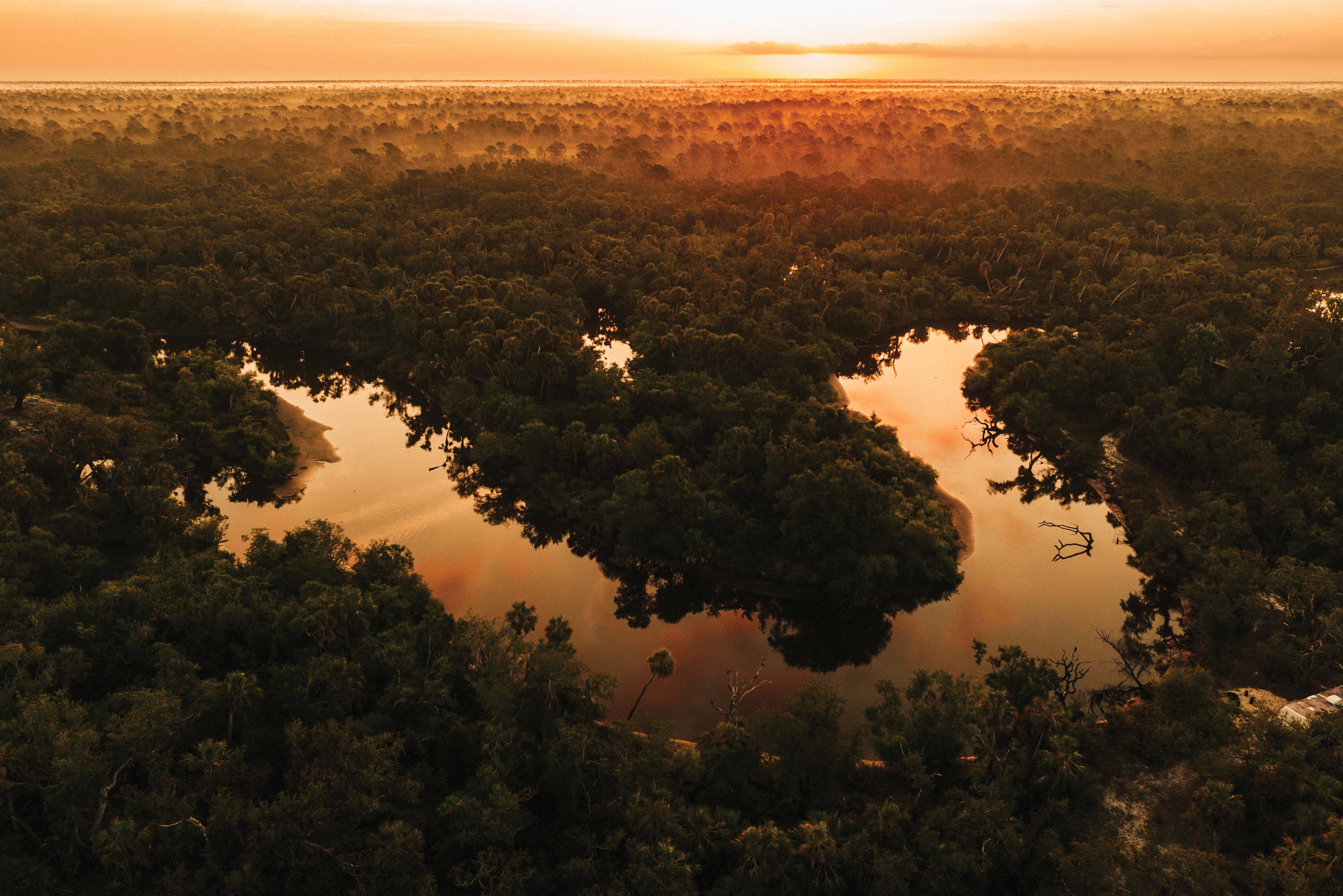
It was daybreak when we slipped our kayaks into the river. Mist rose from the calm surface of the water, illuminated from behind by the sunlight peeking through the trees. Fish jumped with joy, and a great blue heron enjoyed a piscatorial breakfast. There was no flow in the river, as rain had been in short supply. Fallen oaks and palms told a story of last season’s hurricanes. The air was fresh and cool while songbirds and cicadas provided a soundtrack for our journey. My paddling partner for the day was a good friend with plenty of on-the-water experience. It was hard to believe that just 30 minutes earlier we had loaded up our kayaks and left civilization behind. We were on the Wild and Scenic Myakka River, the only river in Florida honored with the designation.
The Myakka is not a paddle trip most kayakers in Sarasota take. Popular excursions steer people to the coast, to Lido Key’s famous mangrove tunnels, or to local creeks and shallow bays. The Myakka remains a mysterious, undiscovered territory on the eastern side of our coastal communities, providing a different paddling experience. Here, surrounded by natural lands both private and public, it is possible to be completely enveloped in nature.
Kayaking the Myakka is also not a singular experience, as every visit and stretch of the river changes with the weather and the landscape. Paddling within Upper Lake in Myakka River State Park is a different experience from paddling along the edge of the T. Mabry Carlton Jr. Memorial Reserve or exploring the waters near Snook Haven. Some places offer expansive views of shimmering wetland marshes spreading across a wide flood plain; some are intimate corridors where you must pick your way carefully through the narrows. Each stretch of the river has its own beauty, personality and challenges.
River conditions provide an even greater diversity of experience, and this is where planning and common sense are needed. When the water levels are high, optional routes appear as the water overflows its banks, and it is hard to tell where the river is. Getting lost is easy, and there are no street signs to guide you. Knowing your ability and the mood of the river is essential to a safe and enjoyable experience.

Image: Gene Pollux
Stretching from its source in a swamp, created by rainwater, near the Manatee-Hardee county line to where it empties into Charlotte Harbor, the 70-mile-long Myakka meanders through the heart of Sarasota County. The river has been flowing here since the last ice age, when the peninsula of Florida was twice as wide, and mastodons and saber-toothed tigers roamed the land. Archaeological studies of Warm Mineral Springs and Little Salt Spring, both in North Port, document Paleo-Indians living near
the river more than 10,000 years ago. Their descendants fished, hunted and camped along the river for thousands of years.
In the early 1500s, Ponce de Leon’s expedition landed at Charlotte Harbor, which may have been the first time Europeans explored the Myakka. By the mid-19th century, the Seminole tribe was raising cattle along the river prairies; eventually, the region supported one of the largest cattle ranges in the United States and later became a destination for wealthy sportsmen seeking wilderness hunting, fishing and camping. In the 1930s, Bertha Palmer’s cattle ranch, Meadowsweet Pastures, became the nucleus of Myakka River State Park. Since the 1980s, thousands of acres of natural lands adjacent to the river have been protected. The collective set of public lands and conservation easements along the Myakka River preserves more than 70,000 acres in the Myakka’s watershed.
During a normal rainy season, millions of gallons a day flow through this river, and its path influences the geographic boundaries of all three counties it passes through. When Desoto County split from Manatee County in 1887, the northern boundary of DeSoto was placed so that the new county could proudly claim a portion of the river. When Sarasota County sought to split from Manatee County in 1921, the biggest stumbling block was determining how much of the river would stay in Manatee and how much would be included within the new boundaries
of Sarasota.
Today, about 34 miles of the Myakka flows through Sarasota, and what makes this portion of the river so unique among all Florida rivers is that it has been protected from development. Instead of paddling through a canyon of big riverfront homes and condos, or gliding by a manicured golf course, the river remains wild, and that is due to visionary leaders who saw its value as nature’s gift.
In 1985, the Florida Legislature adopted the Myakka River Wild and Scenic Designation and Preservation Act. This act called for the creation of a management plan, a management coordinating council, changes to local government comprehensive plans and rulemaking authority that will protect the river as wild and scenic for today and in the future. It is the only river in Florida with the title and was a massive achievement. From space, this natural treasure looks like a westward-pointing, big green arrow in the heart of the county.
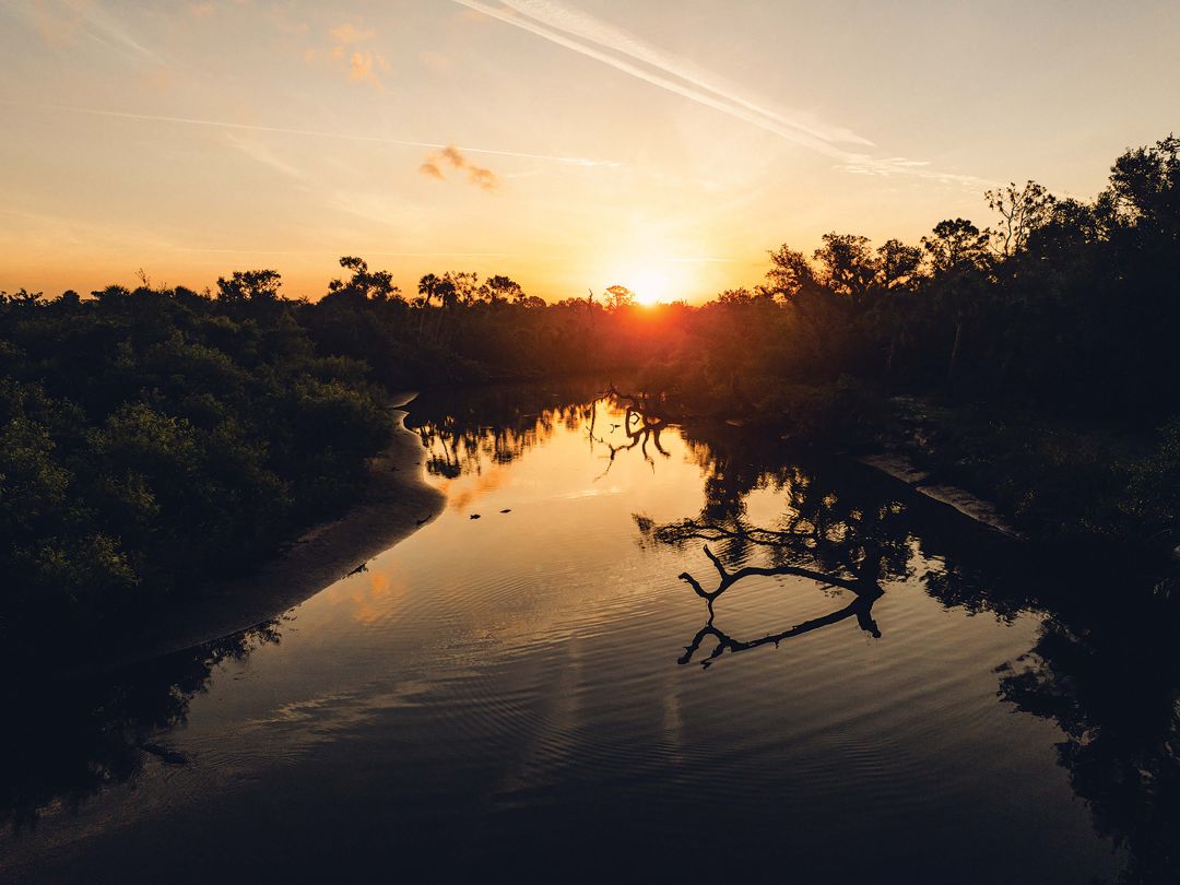
Image: Everett Dennison
Our morning on the Myakka started inside this big green arrow at the Venice Myakka River Park off Laurel Road in Venice—essentially the mid-point of the river in Sarasota County. There are other ways the public can enter the river (see sidebar, page 65), but we chose this park because it provides restrooms and a convenient launching system mounted to a floating dock. We launched into a protected cove, about 100 feet wide, that opens to the main stream of the river. Our destination was Rocky Ford, a beautiful, shallow area with a limestone rock bottom that was an old crossing for cattle drives and pioneers long before bridges spanned the river. Only a few miles as the crow flies, we would be paddling twice that distance—about six miles—a journey we estimated would take between four and six hours.
But we had no timetable in mind. The low water level and virtually no river flow allowed a leisurely paddle, with no current to fight. While my preference is always to go upstream first, with the assumption of an easier return, we could have gone in either direction. This year’s drought conditions were a stark contrast to the conditions that prevailed during last year’s storms. Shady oaks and horizontal palms that had cantilevered over the river for decades had been washed away by raging waters. The only plants that seemed to resist the storm flow were the Carolina willows, providing welcome shady spots for us and the hundreds of shade-loving water bugs scurrying around the surface of the water.
This stretch of river has many twists and turns, with steep banks along one side and ever-changing sandbars on the opposite side. The banks, ranging from 6 feet to 12 feet high, are made of limestone, providing a glimpse back millions of years to when Florida was the ocean floor. These banks were scoured from last year’s floodwaters, laying bare Florida’s ancient geological history in freshly exposed sediments that looked like a layer cake: yellow rock, white shell and tan sand with a chocolate frosting of brown soil at the top. At each bend in the river, the shoreline flip-flops, with the steep banks on the outside of the flow, and sandbars on the inside track of the flow.
On this cool morning, the alligators were skittish and shy, launching from their sunny sandbars and bolting toward the shade of fallen trees on the opposite bank. This was OK with me, as one of my biggest fears is running my kayak up on the back of one of these ancient reptiles and finding myself in the water. The turtles, on the other hand, were content to watch us paddle by, perched with legs outstretched on fallen logs just breaking the surface of the water. A Seminole name applied to a portion of the river translates to “Sleeping Turtles”—it’s both descriptive and timeless.
Turning a corner, we found a long stretch of the river with hurricane-tossed trees, some crossing the entire width of the stream. While the bank-to-bank width of the river was wide, the channels available for kayaking became less obvious, and in some cases just wide and deep enough to sneak through. I let my friend take the lead and thread the needle.
While we got into some tight areas and scraped bottom on a few submerged trees, there was no water pushing us, and we were always in complete control. This is not always the case, and it is common to get in a bind when the river is flowing and the submerged trees are less obvious.
A silver lining to the fallen trees were the little micro-gardens that were growing out of emergent oak limbs and palm trunks. Like miniature islands, these little habitats boasted bright green grasses and colorful flowers that attracted bees, butterflies and dragonflies. The same was true of the sandbars, many of which were covered with verdant groundcover and a bouquet of white, yellow, pink and purple flowers. You don’t have to be a botanist to enjoy their brilliant beauty.
Along the way we came across a community viewing platform and two rustic waterfront homes, built many years ago. During our entire five-hour trip, these were the only examples of civilization that broke the solace of pure nature. While seeing these modern landmarks in this setting felt out of place, they allowed calibration with my map. Beyond those structures, the river embraced us with wetlands and oak and palm hammocks, giving way to more elevated pine flatwoods beyond. We celebrated that we could no longer hear a hint of I-75.
Eventually, the clear water revealed a rocky bottom, indicating we were nearing our goal, but given how shallow it was, we weren’t sure we could navigate to our anticipated lunch spot. The pattern of rocks on the bottom was like a coral reef, not something you wanted to drag your boat through. We maneuvered over the rocks, and in a few minutes, we pulled our boats up on the sandy shoreline just south of the cattle crossing. This is one of my favorite spots on the river, combining geology, history and natural beauty.
We wasted no time in breaking out homemade sandwiches and ice-cold root beer, which we enjoyed standing up, happy to be able to stretch our legs after two-and-a-half hours of paddling. (I always keep a modest-sized cooler in my boat. I like to be comfortable when I am roughing it.) After walking up the eastern bank to the trail that used to be a highway for cattle, I was reminded of all the times I hiked to this location and how great it was to approach it from the river. We explored the ancient geologic features of the natural ford and took photos of the contrast between the soft bright green carpet of the sandbars and the sharp rough edges of the rocky limestone outcropping. It was now 10:30 a.m. and time to make our return trip, so we slipped back into the river, with bellies full and plenty of morning still ahead of us.

Image: Everett Dennison
Paddling back, the sun was higher and the light had changed. The chirps of woodpeckers and songbirds were enhanced by the shrill cries of red-shouldered hawks soaring overhead, hunting for brunch. Everything felt brighter and warmer. As the heat increased, so did the sea breeze, blowing head on and cooling us off more than if it had at our back. The tide was rising, and some of the tight areas we experienced going upstream were easier to navigate going down.
By 12:30 p.m., we were close to our take-out and meandered at about one mile for an hour until we reached the cove that had greeted us at daybreak. As we hauled our boats from the river, my friend and I reflected on the profound experience of encountering the river as people have for thousands of years—with provisions in our boats, adventure in our hearts and appreciation in our souls.
Opening photo by Everett Dennison
Native Floridian and outdoorsman John McCarthy is the vice president for regional history at Marie Selby Botanical Gardens and is a former director of Sarasota County Parks and Recreation.