


Hidden in Plain Sight, Phillippi Creek is Rich in Nature and History

Image: John McCarthy
Driving around Sarasota, we’ve all caught glimpses of Phillippi Creek, a narrow ribbon glinting behind a shopping center or beneath a busy highway. Yet although it’s surrounded by suburban development, a kayak journey along the creek is surprisingly rich in nature and history.
On a winter morning, we launch our kayak near the mouth of the creek, where it intersects with Roberts and Little Sarasota bays. Here is one of the largest mangrove areas along Sarasota’s coast. In the early days, it extended from the mouth of the creek to what’s now called Siesta Key, providing a low-tide causeway linking the mainland to the key. But only shallow-draft vessels at the highest tide could pass through the mangroves. Dredge projects, beginning in the 1890s and capped by the dredging of the Intracoastal Waterway in the 1960s, finally opened the area to navigation.
The sun is rising in the east, and across the smooth, shimmering water, a reddish egret performs its fishing dance, wings spread wide. Farther away, a yellow-crowned night heron hunts along the shoreline. We head upstream.
Phillippi Creek is one of Sarasota’s oldest landmarks, named for Phillipi Bermudez, whose nearby Spanish fishing rancho, established in the early 1800s, satisfied Cuba’s hunger for seafood and fed the local economy for decades. The once meandering creek has changed dramatically since then, as it was ditched, dredged and dammed for development from the 1880s through the 1960s.
While not as wild or scenic as the Myakka River, Phillippi Creek is one of the area’s largest coastal streams. Flowing south and west from its upper reaches in the historic sawgrass marshes near Fruitville, the creek takes many forms along the way.
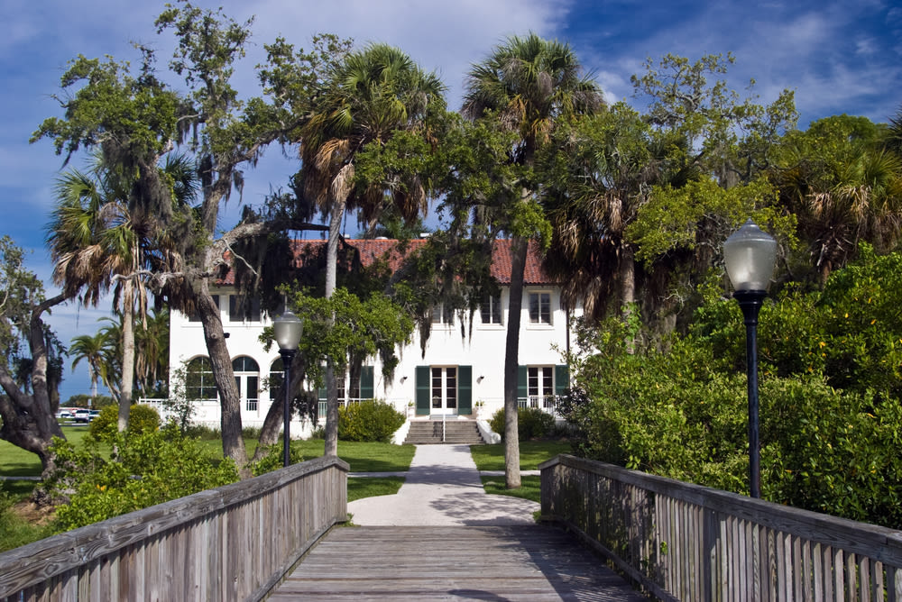
The Edson Keith estate on the creek was built in 1916 and is now on the National Register of Historic Landmarks.
Image: Steve Carroll/Shutterstock
As we paddle, mullet scatter from our path, and we pass through some of Sarasota’s oldest and most iconic subdivisions. What is now Phillippi Estates Park was developed in 1911, attracting wealthy newcomers from Chicago. First purchased in 1883 for $50, the land was inhabited for thousands of years by Native Americans, who left their shell middens and artifacts behind. In 1916, Chicago merchant Edson Keith built the area’s first Mediterranean-style mansion here. The property was purchased by the county in the 1980s.
A bit upstream is River Forest, established in 1955. Despite all the manmade changes over the years, we notice that as the creek bends northward, two little coves formed from hundreds of years of alluvial sand deposits are just as they are on the 1883 coastal chart, and the wooded shorelines provide a striking glimpse of the creek in its natural state.
Around another bend lies the Maine Colony, a neighborhood established in 1916, prompting one of the creek’s first navigational dredging projects. Farther upstream are the communities of South Gate and Forest Lakes, both occupying the former Hyde Park Citrus Subdivision, a development of 10-acre groves that once spanned 1,000 acres in the heart of Sarasota.
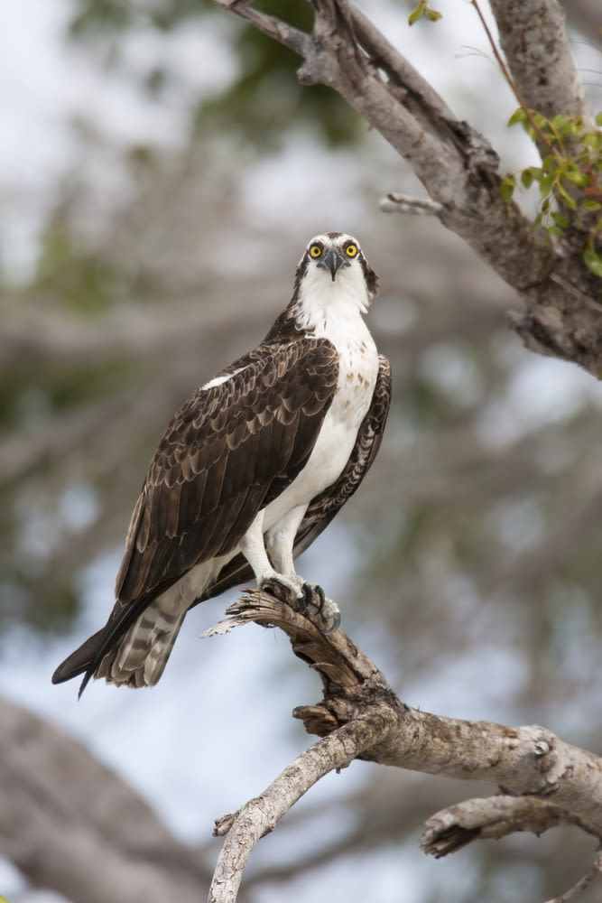
An osprey perches along the shore.
Image: Stubblefield Photography
As we twist and turn our way upstream, the creek is a quiet suburban oasis, hidden from the outside world. Native habitats, colorful landscaping and homes tucked back from the shoreline create a picturesque setting, while docks, boats and backyard art add variety. Ancient pines exhibit scars from the turpentine industry and have provided perch trees and nesting areas for generations of bald eagles. Freshly fallen flowers sail lightly on the surface of the water, pushed by gentle breezes and the incoming tide.
We pass such landmarks as Riverview High School and the Southgate Community Center, designed by famed Sarasota School architect Victor Lundy. Just beyond the community center is one of the most visible results of early drainage projects, a concrete dam installed to block the tidal salt water almost 100 years ago. It allowed creek water to be pumped in to irrigate the citrus groves. The dam was opened to water flow in 1961 to alleviate flooding. Today, small boats can pass right through, and tidal salt water can flow higher up into the watershed. The water at this point of the creek is brackish, and we spot freshwater “slider” turtles sunbathing on exposed logs.
As Florida real estate boomed in the teens and early ’20s, workers built ditches and graded roads along the creek, occasionally unearthing remnants of history. In April 1916, surveyor William Tuttle discovered the fossilized remains of a Pleistocene-era mastodon. Years later, paleontologist J.E. Moore found mastodon remains farther upstream, and in 1929, he discovered fossilized human remains that appeared ancient. This long-ago creek resident was dubbed “Phillippi Man.”
Between Bee Ridge Road and Tuttle Avenue, the creek becomes a dredge-straightened channel, while the old meandering path is now a wildlife-rich wetland. We savor other sights, including clumps of giant leather ferns, ancient live oaks shading the shoreline and ospreys soaring in search of a meal. We don’t see any alligators, although they’ve been reported in portions of the creek.
As the creek is crisscrossed by busy local roadways, the bridges provide locational reference points along our journey. Going upstream, we pass under the Tamiami Trail, then Proctor Road, Bee Ridge, Tuttle, Webber, and, near our journey’s apex, the bridge at Bahia Vista in Pinecraft. In contrast to the peaceful stretches of much of the trip, the bridges rumble with automobiles, bringing us back to the present time.
After decades of dredging and widening, the once slow-moving creek, which drained rainwater slowly into natural wetlands, became a fast-moving channel surrounded by manmade marshes. Heavy rains, which the creek basin in its natural state would have absorbed, now poured downstream all at once, flooding houses and nearby neighborhoods and raising pollution levels in the bays. And by the 1960s, discharges from a network of small utility plants along the creek added to a water quality crisis. By 1979, Phillippi Creek was declared one of Sarasota’s most polluted local waterways. Today, a variety of engineering and pollution-reduction actions have had a positive effect; the waters in the creek look and are much cleaner than they were when I first kayaked here in the late 1970s.
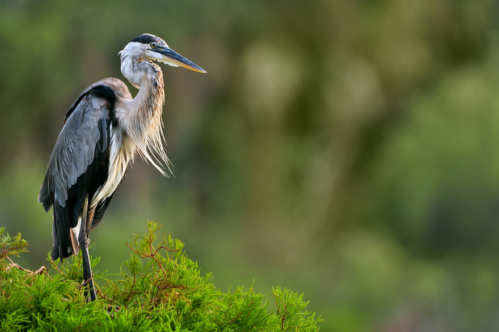
A blue heron stands by the shore.
Image: FloridaStock/Shutterstock
We pass by a forested preserve that includes one of the rarest habitats in the county—an area of mature elm and hickory trees—and arrive at Pinecraft Park. In 1925, the land here was platted as the Sarasota National Tourist Camp, with a grid of small lots intended for visitors with travel trailers and camper automobiles. Amish and Mennonite visitors began arriving and some settled year-round in the area.
Although the popular restaurants of Pinecraft are just steps away, we’ve brought our own lunch, which we enjoy in the boat. As we reverse our course for the trip back downstream, we reflect on the ecology, hydrology and history of one of Sarasota’s most prominent and underappreciated natural assets. Heavily impacted and yet remarkably resilient, Phillippi Creek is hidden in plain view, and easily accessible to those who seek it out.


